Forte Minerals Corp.CSE: CUAUC$—OTCQX: FOMNFUS$—FSE: 2OA€—
Porphyry Copper–Molybdenum Southern Peru

Hidden Beneath Cover

Esperanza.

A 4,000-hectare exploration project in southern Peru’s Paleocene belt. Mapping, geochemistry and geophysics support an interpreted porphyry target that remains untested by drilling.

Commodity
Copper · Molybdenum
Area
4,000 ha
Status
DIA Approved
Trace the Evidence
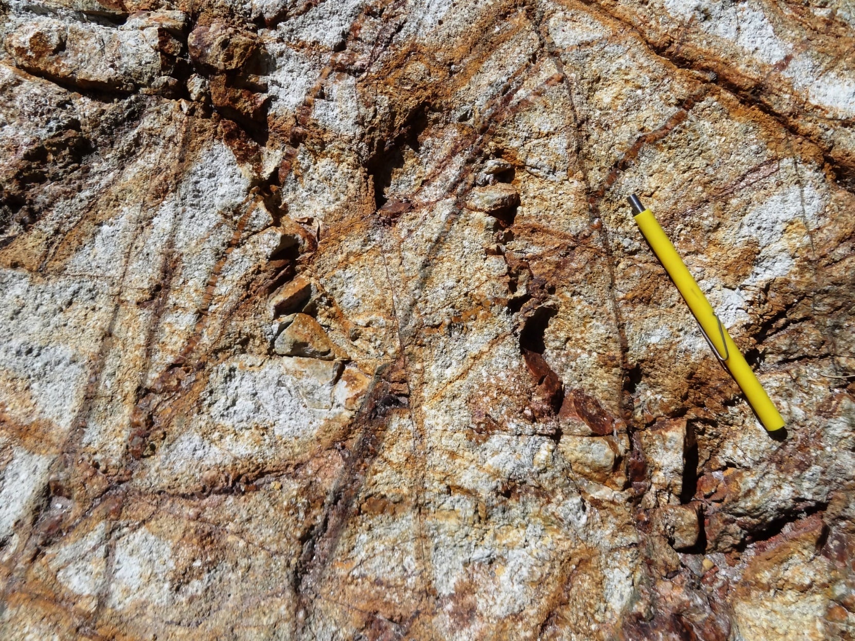
Multiple early to late stage veining events in potassic-altered granodiorite host rock at Esperanza, with a pencil for scale
Figure 8Veining in Potassic-Altered Granodiorite
Mapped Porphyry Footprint
4.2 × 3.1km

Constrained by geologic mapping

Property
4,000ha

In southern Peru’s Paleocene magmatic arc

Ownership
100%

Forte ownership, subject to a 1% NSR royalty

Potassic Zone
2.8 × 1.7km

Inferred from integrated exploration patterns

Drill History
Zero

The interpreted system remains untested by drilling

Qualified Person and NI 43-101 Disclosure

Richard Osmond, P.Geo., an Independent Director, is the Company’s Qualified Person (“Qualified Person”) as defined by National Instrument 43-101.
He has reviewed and approved the technical information contained on this page.

Summary
Esperanza (Porphyry Cu-Mo)

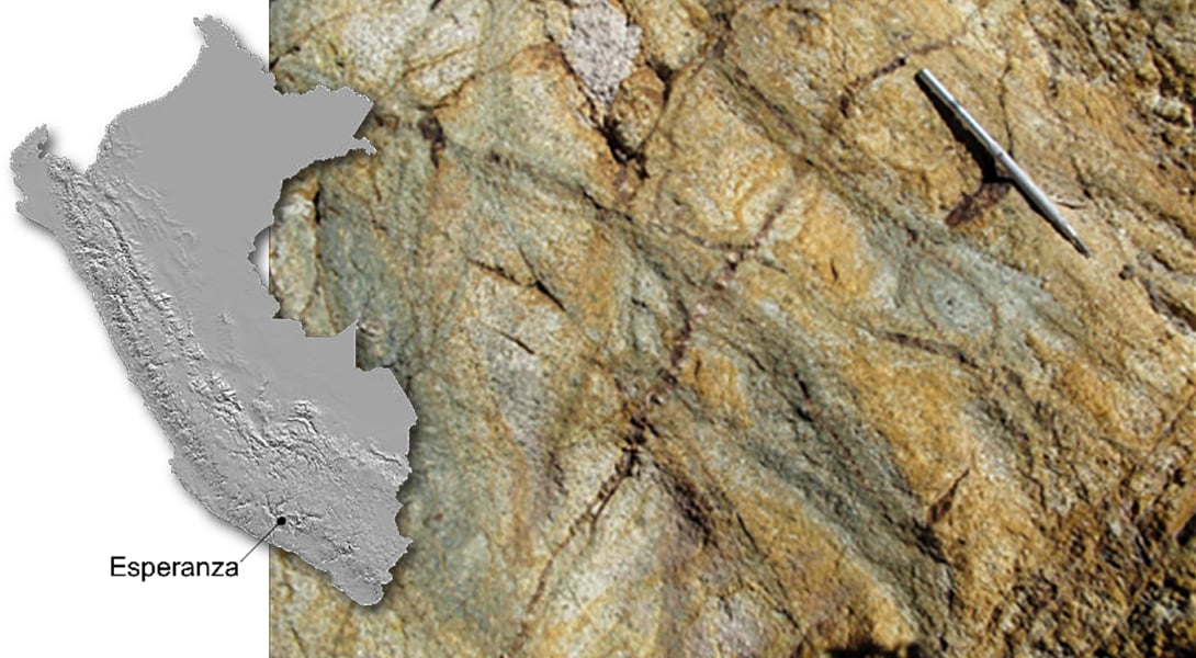
Map of Peru marking the Esperanza location in the south, beside an outcrop photograph of veined granodiorite with a pen for scale
Esperanza Location, Southern Peru
  • 4,000 ha property in the Paleocene magmatic arc. 100% Forte Minerals
  • 2.8 x 1.7 km potassic zone is inferred from geological, geochemical, and geophysical patterns
  • Prospective for supergene-enriched and hypogene (sulfide) Cu mineralization
  • Untested by drilling
  • Porphyry footprint measuring 4.2 x 3.1 km is constrained by geologic mapping

Esperanza is located in the Paleocene belt of southern Peru which is well endowed with some of the world’s most prolific copper deposits.

Existing porphyry copper mines coupled with recent discoveries from exploration make this an optimal region for copper exploration, discovery, resource development and permitting.

Commodity
Copper · Molybdenum
Deposit Type
Porphyry Copper–Molybdenum
Area
4,000 ha
Ownership
100% Forte Minerals
Status
DIA Approved

The information can also be viewed in the NI 43-101 Technical Report on the Esperanza Property, filed on SEDAR+ in November 2021.

Project Overview

The Target Is Hidden.
The Evidence Is Not.

Approximately 80% of the Esperanza system is interpreted to lie beneath post-mineral volcanic cover. Around its exposed margins, alteration, copper geochemistry and geophysical responses define a coherent porphyry-scale target.
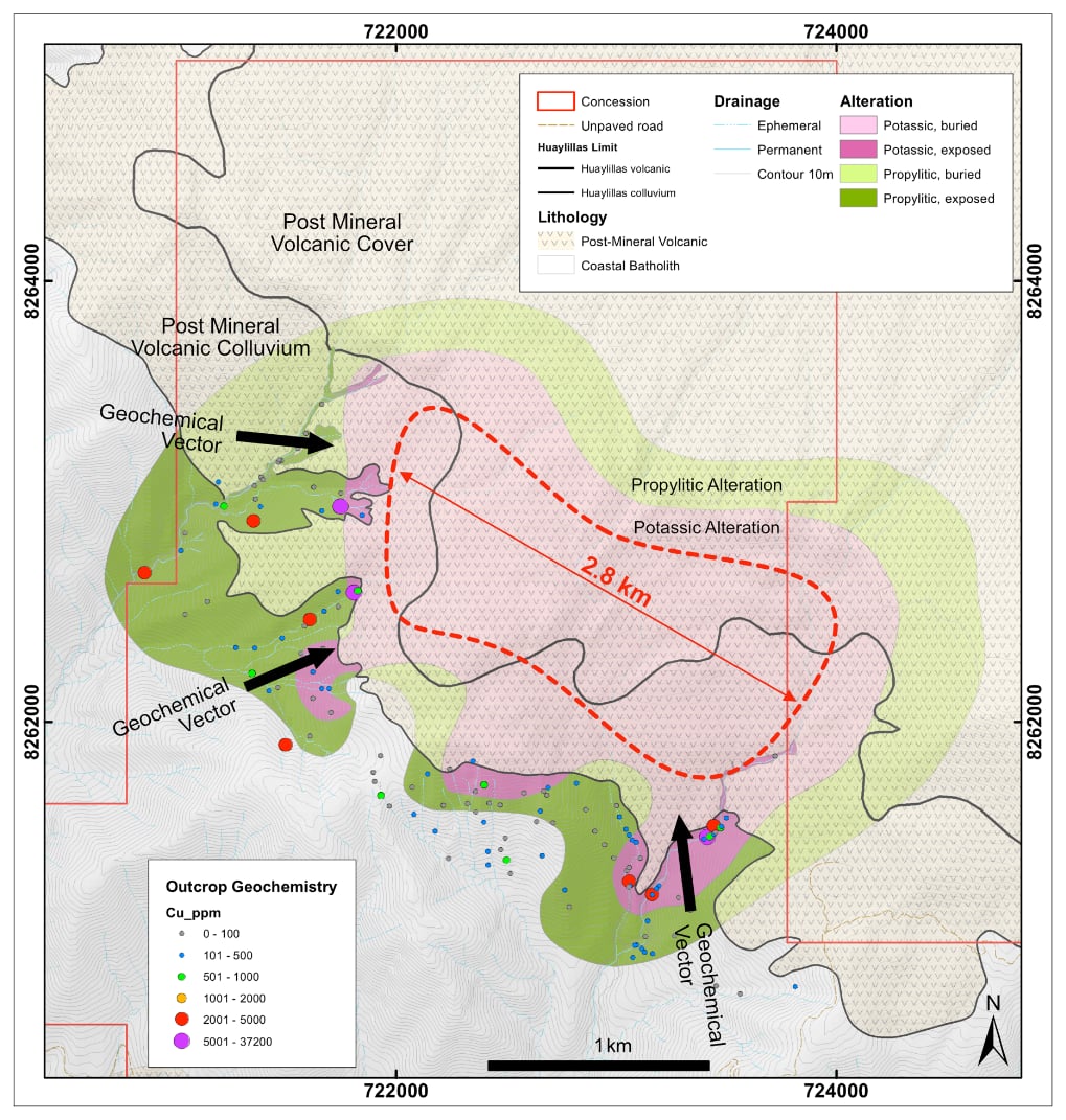
Esperanza map of alteration and outcrop Cu geochemistry showing exposed and buried potassic and propylitic alteration, geochemical vectors, the 2.8 km inferred potassic zone and post-mineral volcanic cover
Alteration and Outcrop Cu Geochemistry · Plan View
The Exploration Thesis

A Porphyry Centre Beneath a Volcanic Veil.

The potassic zone is exposed along the edge of younger Huaylillas volcanic cover. Geological vectors continue toward the covered area, supporting an interpretation that the centre of the system extends beneath it.

Forte considers the property prospective for both supergene-enriched copper and deeper hypogene sulfide copper mineralization.

Geology

Mapped alteration and veining outline the system.

Geochemistry

Surface copper anomalism strengthens the vectors.

Geophysics

Resistivity and magnetics extend the model under cover.

Regional Setting
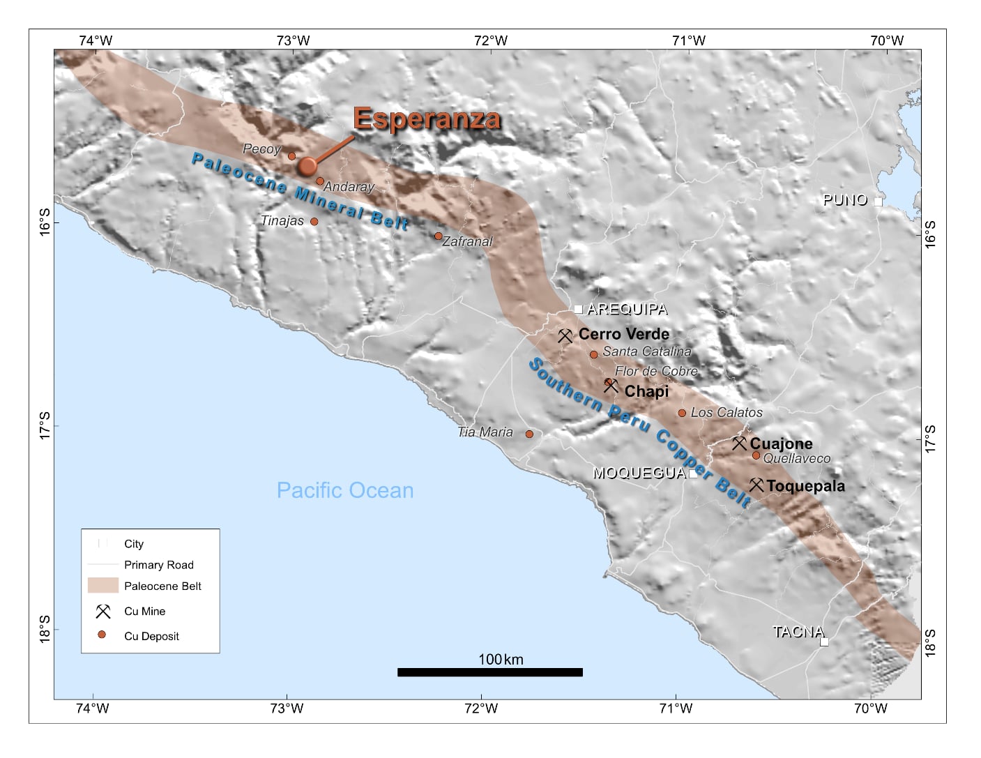
In the Path of
Peru’s Copper Belt.

Map of southern Peru's Paleocene mineral belt showing Esperanza and nearby copper mines and deposits including Cerro Verde, Chapi, Cuajone, Toquepala, Pecoy and Andaray
Esperanza is located in the Paleocene belt of southern Peru. The existing porphyry copper mines coupled with recent discoveries from exploration make this an optimal region for copper exploration, discovery, resource development and permitting.
Regional Setting – Paleocene Belt of Southern Peru

A Productive Address for Porphyry Discovery.

Esperanza lies within the same regional belt as long-lived copper operations and more recent porphyry discoveries. The system is emplaced into the Coastal Batholith along a major crustal structural corridor that also hosts the nearby Pecoy porphyry project.

Geological Belt
Paleocene magmatic arc
Host Setting
Coastal Batholith
Relative Elevation
700–800 m above Pecoy
Local Support
Supportive communities

Target Footprint

Three Datasets.
One Buried Target.

The working model is built by reading the same covered ground three ways. Each layer provides a different clue to the geometry and preservation of the interpreted system.

01

Low Resistivity

Interpreted as deep weathering promoted by phyllic alteration beneath a resistive veneer of Huaylillas colluvium.

02

Low Magnetic Susceptibility

A discrete magnetic-low body helps map the footprint of the porphyry complex below cover.

03

Alteration + Veining

Potassic alteration exposed at the cover edge and mapped geological patterns provide the surface control.
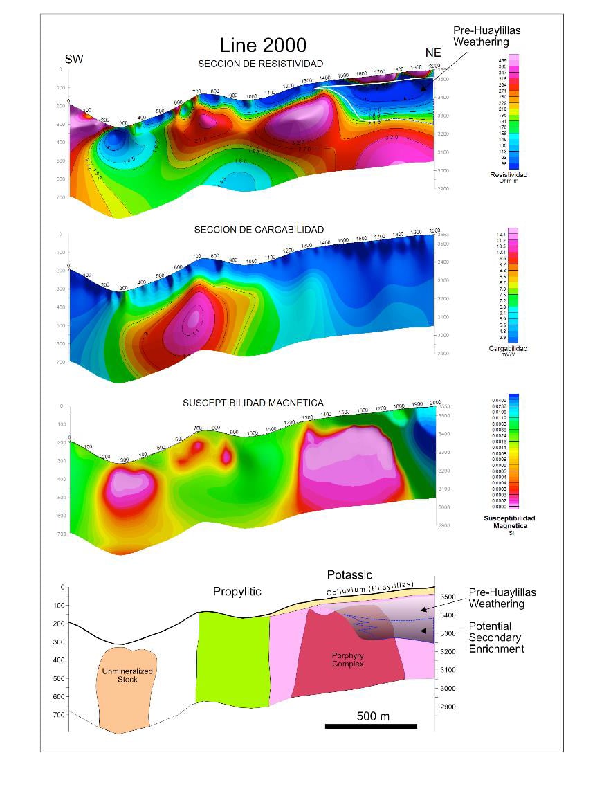
Esperanza Line 2000 resistivity, chargeability and magnetic susceptibility sections, SW to NE, above a conceptual section showing propylitic and potassic zones, the porphyry complex, pre-Huaylillas weathering and potential secondary enrichment
Line 2000 Geophysical Sections and Conceptual Model · Interpretive, not a mineral resource
Geophysical Interpretation

Reading the Target Under Cover.

  • Geophysical response aids interpretation of under-cover target resistive veneer maps Huaylillas colluvium.
  • Low resistivity represents deep weathering promoted by phyllic alteration.
  • Body with low magnetic susceptibility maps porphyry complex.
  • Geological patterns (alteration, veining)
  • Porphyry system is emplaced into Coastal Batholith.
  • Potassic zone exposed on edge of post-mineral cover
Multiple early to late stage veining events in potassic-altered granodiorite host rock, with a yellow pen for scale
Figure 8 - Multiple early to late stage veining events in potassic-altered granodiorite host rock.

Target Identification

The Cover Keeps
Leaving Clues.

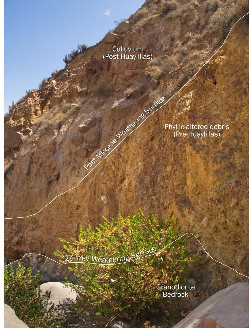
Esperanza exposure showing post-Huaylillas colluvium above a post-Miocene weathering surface, pre-Huaylillas phyllic-altered debris, a 24 m.y. weathering surface and granodiorite bedrock
Phyllic-Altered Debris Beneath Post-Huaylillas Colluvium
Field Observation

Eroded Alteration Points Back to Its Source.

  • Exposure of debris from an eroded sericite-pyrite alteration zone indicates a porphyry centre buried beneath post-mineral volcanic cover.
  • Pre-depositional weathering of debris fragments indicates potential for supergene enrichment of the buried porphyry centre.

This remains an exploration concept to be tested, not a statement of a defined mineral resource.
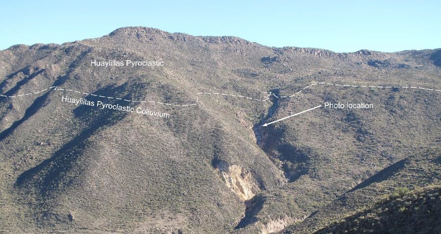
Esperanza hillside showing Huaylillas pyroclastic rocks above Huaylillas pyroclastic colluvium, with an arrow marking the photo location
Huaylillas Pyroclastic Cover over the Target Area

Exploration Readiness

Defined Enough
to Test Next.

Environmental ApprovalDIA

Received December 2023

Esperanza has environmental drilling approval and supportive local communities. The project remains untested by drilling, preserving the full discovery question at the heart of the target.

Forte identified a magnetotelluric survey as the next step to refine drill targeting beneath cover. MT can add deeper resistivity information to the existing geological, geochemical and geophysical model before drill locations are finalized.

Next Targeting LayerMT

Planned magnetotelluric survey

Project-stage note: no drill results or mineral resource have been reported for Esperanza. Target dimensions and geological concepts shown on this page are exploratory interpretations.